3D mapping of Oldham landowners in 1829
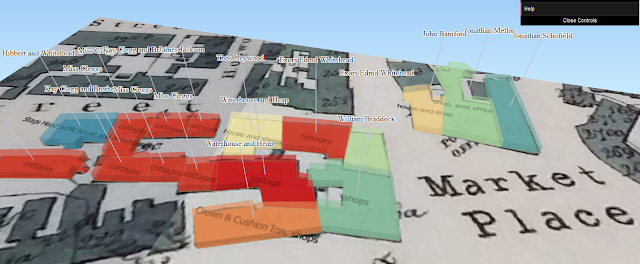
I'm currently trying to make a 3D model of Dunn's map of Oldham in 1829. Here are two versions: http://protesthistory.org.uk/oldhammaps/Oldham_Dunn_3D_earth.html http://protesthistory.org.uk/oldhammaps/Oldham_Dunn_3D_map.html Dunn's map of Oldham 1829 It's easier to navigate on a touch screen. If you're on a standard PC then zoom in by pressing ctrl + shift and the up button. Still work in progress as I haven't entered the whole of Dunn's index of landowners and occupants. Quick summary of how to do it: 1. geo-reference the map in QGIS 2. draw the polygons of the buildings, remembering to add a column in attributes for number of floors. I've estimated this as I don't know the real heights, so for cottages I've put 2 floors, houses 3 floors and big buildings like factories and churches I've put 6 to make them stand out. 3. use the 'threejs' plugin in QGIS. This automatically converts the floor heights into the z co...