Posts

Showing posts from October, 2011

Pubs of Manchester

I've been trying to plot the pubs in Manchester and Salford who signed a declaration in September 1792 against seditious meetings and publications being held in their premises. I've been able to identify just 39 pubs for definite (out of a total of 158 listed in the World newspaper, 22 September 1792), and I've a rough idea of where another 20 or so were. Ten pubs had female landladies. Green's 1794 map and Pigot's directory are a help for locating pubs, and I also conducted some guess-work from later maps [pubs come and go, but their courts generally keep their original names] Trouble is there are so many Red Lions and White Harts that it is difficult to pin many pubs down for definite. Yet lo and behold, I find this site: http://pubs-of-manchester.blogspot.com/ which is a completely comprehensive list of all the old pubs in Manchester, together with links to google street view of where they were located. Things have gone a long way from those (admirable at t...
Collating data using google fusion tables

Meeting places in Manchester, 1775-1848: link to google fusion table Total percentages of all public meetings in Manchester, 1775-1848, that I've recorded from newspapers, Home Office correspondence, and local archives, listed by broad type. This is in no way complete. I have 391 records plotted by place, but I have not gone through all sources systematically, and there are many places (particularly pubs) that I cannot find exact locations either on maps or in trade directories - i.e. an address of simply 'Deansgate' is not much use. Furthermore, the categories are not definitive (i.e. some meetings could cover more than one category). The data generally does not cover private meetings, regular meetings like weekly friendly societies, and secret meetings (i.e. in back rooms of pubs). It is therefore only representative of events that were publicly advertised or involved many people so that they were recorded in the press. Radical and Chartist meetings are likely to b...

old footpaths in Manchester

Image
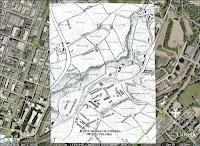
Another messing around with google earth and old maps session. Here I've highlighted a footpath on Green's 1794 map of Newtown, Manchester. Link to the video here: http://screencast.com/t/kMOt7WR6 I like how the fields are all drawn with landowners' names, and that despite this becoming one of the factory districts of Manchester, some of the area is still fields, of sorts, around the River Irk. View Larger Map   Get Directions   View Bird's Eye

locating London's past

http://locatinglondonspast.wordpress.com/ is an interesting blog about a JISC funded project to "map and visualize textual and artefactual data relating to seventeenth and eighteenth-century London against a fully rasterised version of John Rocque’s 1746 map of London and the first accurate modern OS map (1869-80)."